Recent step changes in satellite Earth observation (EO) technologies now provide greater opportunities to see back in time and to use air and space images as evidence. Because of this the world’s first “space detective agency”, called Air and Space Evidence, has been established in the UK to use data from EO technologies as evidence in legal cases. The company aims to specialise in providing evidence in environmental and planning law cases anywhere in the world.
The company was set up by a former environmental law academic (Ray Purdy) and an earth observation academic (Ray Harris) at University College London. Their academic research work at UCL found that the opportunities for evidence collection presented by Earth observation would become progressively more important to those working in the legal, law enforcement, auditing and insurance sectors. But they also found that many of those working in these sectors had little awareness, knowledge and understanding of what EO technologies can offer, its limits and its value as evidence. It is highly likely that whilst most environmental/planning lawyers and legal enforcement officials would have never consider using it in a legal context. Over the course of time Ray Purdy received a number of calls each month at UCL from law firms (both in the UK, US and further afield) and regulatory bodies asking how they might get imagery, which could potentially be used in evidence in legal disputes. They had no idea where EO imagery could be sourced from or the evidential implications of using it. Spotting a gap in the market, Air & Space Evidence Ltd was established to bridge the link between the imagery from these technologies and those working in a legal context; and provides assistance in sourcing and using Earth observation imagery as evidence.
The company use archived data to go back in time and seek to produce evidence that could assist a legal case, a criminal investigation or an insurance claim. They can provide evidence showing when a wetland was destroyed, the timings of an illegal act (taking place outside) e.g. an illegal landfill, or the dates of a development or change of use in a planning law context. There are huge numbers of environmental and planning laws that could be potentially monitored from space. They can use a range of data depending on the clients needs – including the best cutting edge 25cm very high resolution satellite data (good enough to see a manhole cover). Depending on what a client requires we can probably source “before”, “during” and “after” images at an affordable price (e.g. about the same cost as a house building survey).
No other international company offers the high-quality holistic approach that combines legal expertise and a detailed knowledge of Earth observation technology. Air and Space Evidence can source imagery and interpret its findings, but can also offer advice on data policy issues; the management, control and authentication of imagery to be used as evidence (including appearing as expert witnesses in court); the assessment of the correct technical procedures to apply to Earth observation data; implications of privacy legislation, search warrants and compatibility with legislation such as the Regulatory Investigatory Powers Act; and the implications of implementing EO monitoring into regulatory programmes.
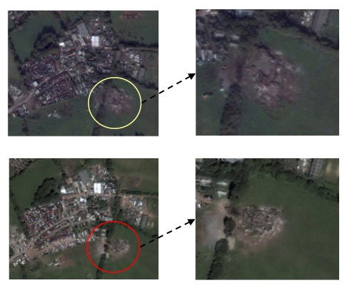
The above images are an example of some of Air & Space Evidence Ltd‘s work and demonstrate the timings of an illegal landfill in the UK.